NAO: North Atlantic Oscillation, this is a measure heights over the north Atlantic (Greenland area). Basically a negative NAO means high pressure over the region while a positive NAO means low pressure over the region. During a positive NAO you tend to see the polar vortex (deep area of cold) located over this region. Milder conditions are also likely over the UK with Low pressure to the North and high pressure to the south. High pressure over the UK or to the North East can lead to colder conditions though. A negative phase of the NAO means high pressure to the north with low pressure to the south. The UK generally sees colder conditions (for example a northerly). A –NAO does not always lead to cold though. Sometimes if a NAO is to west based (higher pressure over western Greenland into the Canadian arctic) then milder conditions can be experienced over the UK as low pressure systems attack from the south west.
This is only very basic overview. More details can be seen here
http://www.cpc.noaa.gov/data/teledoc/nao.shtmlhttp://weatherfaqs.org.uk/node/86AO: Arctic Oscillation, this is a measure of heights over the Arctic region. As with the NAO a negative phase is high pressure while a positive phase low pressure. Low pressure and a strong polar vortex is experienced over the arctic during a positive phase of the AO. This is often bottled up there with little going into the mid latitudes. A positive AO is often associated with milder conditions over the UK. This is not always the rule though (e.g. mid latitude highs can lead to colder conditions). High pressure with a displaced polar vortex is associated with a negative AO. Colder air is displaced into the mid latitudes. A –AO is often associated with colder conditions over the UK. This is not always the case though. A –AO and a west based NAO could leave the UK stuck under mild south westerly’s. It’s all about being on the right side of the block!
This is only very basic overview. More details can be seen here
http://www.cpc.noaa.gov/research_papers/ncep_cpc_atlas/8/figures/z500/JFM.z500.ao.gifhttp://www.cpc.noaa.gov/products/precip/CWlink/daily_ao_index/ao.shtmlMJO: The Madden-Julian Oscillation is a measure of tropical disturbances (storms) as they move eastwards around the global tropics. It normally takes 30-60 days. “It has wide impacts around the world. The MJO has wide-ranging impacts on the patterns of tropical and extra tropical precipitation, atmospheric circulation, and surface temperature around the global tropics and subtropics.” (From the NOAA website) The MJO can also have an effect on ENSO conditions (La Nina and El Nino)
(I don’t know much about the MJO (other than it’s measured in 8 phases and is about tropical disturbances as they move eastwards). It is well worth researching though!)
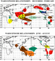
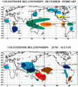
http://www.cpc.noaa.gov/products/precip/CWlink/MJO/MJO_1page_factsheet.pdfENSO: Enso is a climate pattern in the pacific (off the coast of South America). La Nina and El Nino occur in cycles. It has major and wide impacts around the world. El Nino is warmer than average waters. During an El Nino trade winds across the area weaken or sometimes head east (trade winds are the prevailing wind pattern, for example ours is westerly. The normal trade winds for the ENSO region are easterly) I won’t go to technical as not only will I confuse you but I will also confuse myself! During El Nino dry and hot conditions are experienced across much of Australia and South East Asia with South Africa experiencing similar conditions. Wetter conditions are experienced across southern parts of North America with warmer and drier conditions further north. Much of South America apart from the West experiences warmer and wetter conditions. (This is the average Dec –Feb pattern) I have attached a map below. The MJO can affect the speed and development of the El Nino. El Nino is measured in four Zones (see link below) Western based Niño’s are where the warmest zones are to the West while eastern based Niño’s see the warmest waters are locted on the Eastern side. Our winter has seen the warmest waters in the Western Zones. ENSO can be strong, moderate or weak. Mild and wet is often associated with strong El Niño’s in the UK (winter). The warmest year on record (globally) occurred during a strong El Niño event (97/98). El Nino often peaks in the winter.
La Nina is the opposite with colder waters in the Pacific. Trade winds strengthen (easterly) as the cold pool intensifies (again I won’t go to technical). LA Nina is often associated with wetter and cooler conditions across western South America, Eastern North America, as well as southern Africa. Australia and Southern and Eastern Asia often experiences much wetter conditions, Eastern South America and the pacific experience drier and colder conditions. While southern parts of northern America experience drier and warmer conditions. Again MJO can affect La Nina. A strong La Nina can be the kiss of death for UK winters! Again maps have been attached.
 http://en.wikipedia.org/wiki/File:Enso-index-map.png
Stratospheric warming events: During a stratospheric warming event westerly winds at 10hpa (60N) reverse or slow down. The mean temperature also increases. Warming events can disrupt and displace the polar vortex. This can then lead to a –AO forming (can you now see however everything is starting to link??) There are three main types of warming, a major warming, a minor warming and a final warming. A major warming is where the westerly winds completely reverse and the polar vortex is split into different vortices. It is often displaced from its normal position and a –AO forms. During a minor warming the westerly winds only slow down (but do not reverse). For this reason the polar vortex is not split and is only disrupted. A temperature rise is still experienced though at 10hpa, 30hpa etc... A Final warming is self explanatory really. (During the summer the mean average flow is easterly while the winter is westerly) During the final warming the winds reverse back to easterly. There is no further warming event during the summer. I have attached a diagram below. A cold stratosphere means the polar vortex is often cooped up over the arctic with a –AO (see the AO for effects). You will often see people hoping for a warming event because it means the polar vortex will be disrupted or displaced with the chance of a –AO occurring. This then leading to northern blocking and increased cold chances for the UK.
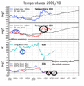
Below show are a few diagrams I have put together. You should be able to understand them if you have read the text

I hope this has been useful for you, please add to it if you wish.


